|
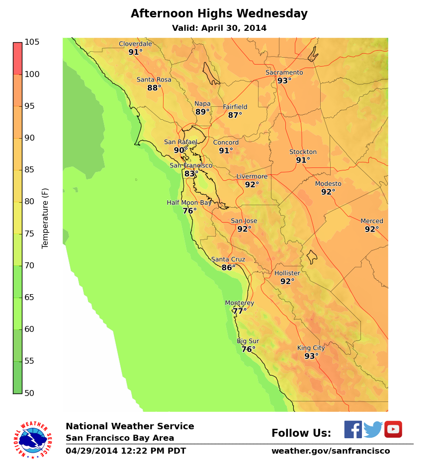
Overview A strong ridge of high pressure over the Western states will produce unseasonably warm weather for the next several days. Temperatures will be warmest on Thursday and highs will be near record-setting with interior locations well into the 90s. This will be the first widespread hot weather of the year. Search #heatwave on Twitter and FB for additional information. |
CONFIDENCE
· High Confidence in near record heat for interior areas
· Low-Moderate Confidence in how close to the coast the 90s are.
UPDATED INFORMATION
- Updated high temperatures Wed/Thu and included info on Records (attached).
TIMING
· Each day this week will steadily get warmer, with Thursday being the warmest day.
· Temperatures will cool considerably by Friday.
LOCATIONS
· Hottest temperatures will be in the interior valleys of the area, especially in the valleys of southern Monterey County. 95-100 in the hottest interior valleys.
· Cooler on the immediate coast, but even 75-80 degrees in coastal locales.
· Overnight lows will remain 50-60 degrees in most locations.
· MAJOR URBAN AREAS:
o San Francisco/Oakland: 75-85 Wed/Thu
o San Jose: 85-95 Wed/Thu
IMPACTS
*Hazards:
· No watches/warnings/advisories in effect at this time. You may see all current watch, warnings, advisories for our area at http://www.wrh.noaa.gov/mtr/fastpage/wwa_bc.php?wfo=mtr
*Impact 1 (Hot Daytime Temperatures) :
· Early season hot weather will produce heat stress on vulnerable populations and those working outdoors. Use caution and take frequent breaks, attempt to avoid being outside during the hottest times of day, drink plenty of water, and check on friends, neighbors, and relatives.
· Sadly, we have already had one death related to heat stroke in a vehicle this year in our area. We want to really highlight to people the importance of not leaving children or pets in an unattended vehicle at all – even with the windows rolled down. Our local partner Jan Null from San Francisco State University has some excellent resources related to this: http://www.ggweather.com/heat/
*Impact 2 (Fire Weather):
· Dead fuels will dry quite a bit this week with the very warm temperatures and low humidity. Annual grasses in the lower elevations are likely to cure somewhat in the drier areas this week. Larger fuels have been below seasonal moisture content for some time now and this week’s weather will continue that status.
· At this time, the wind does not appear to be strong enough to create a significantly elevated risk of fire weather.
