South San Francisco, CA January 22, 2016 Presented by the EPA United States Environmental Protection Agency
What is a King Tide?
The king tide is the highest predicted high tide of the year at a coastal location. It is above the highest water level reached at high tide on an average day. King tides are also known as perigean spring tides.
When is a King Tide?
King tides are a normal occurrence once or twice every year in coastal areas. In the United States, they are predicted by the National Oceanic and Atmospheric Administration (NOAA). Learn more about tides from NOAA by using their Tides and Currents map. The Tides and Currents station map can be used to locate stations that provide water levels, meteorological observations, and current observations. NOAA also has resources to help find information about tides in your area.
- Find out when Atlantic and Gulf of Mexico king tides will arrive and how high they will be.
What Makes King Tides Predictable?
King tides occur when the orbits and alignment of the Earth, moon, and sun combine to produce the greatest tidal effects of the year. See a story map from NOAA’s Office for Coastal Management and The King Tides Project to learn about sea level rise and tidal flooding.
What do King Tides Show?
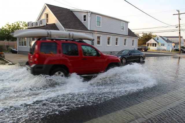
King tides bring unusually high water levels, and they can cause local tidal flooding. Over time, sea level rise is raising the height of tidal systems. Average daily water levels are rising along with the oceans. As a result, high tides are reaching higher and extending further inland than in the past. King tides preview how sea level rise will affect coastal places. As time goes by, the water level reached now during a king tide will be the water level reached at high tide on an average day.
Why Observe King Tides?
King tides provide a glimpse of future everyday water levels, and they are a way to communicate local sea level rise impacts over long time periods. Low-lying shoreline development is at increased risk of flooding because of rising seas, and public investments in infrastructure, housing, and habitat restoration projects are often expected to last for decades. Highlighting king tides in a community can raise awareness of potential sea level rise impacts and identify flood-prone locations. The increased understanding of how sea level rise will impact local resources is valuable information for community decision-makers.
King Tide Initiatives
The idea of using king tides to glimpse the future of sea level rise originated in Australia. Witness King Tides remains an active organization, encouraging coastal communities around Australia to contribute photos to the project. The King Tide Initiative has also spread to British Columbia.
For more information about domestic King Tide initiatives, visit the U.S. Witness King Tides home page.
Use CRE’s King Tides Fact Sheet to learn how to leverage a king tide for a sea level rise education campaign.
Sea level rise will make today’s king tides become the future’s everyday tides.
###
NOTE:
As the EPA warns above ‘Sea level rise will make today’s king tides become the future’s everyday tides.‘ and with the flooding of local areas we can see what the future will bring. With nearly 200 countries signing onto the Global Climate Pact (#ParisAgreement) the seriousness of this issue is before us all.
The County of San Mateo has created a Sea Level Rise Vulnerability Task Force to identify areas prone to flooding and how to remedy concerns along with outreach to our communities. For more information please CLICK HERE. A FREE family friendly workshop will be held at Genentech on Saturday January 30th. More information please CLICK HERE
As you can see from the photos, taken by San Mateo County Harbor District Commissioner Sabrina Brennan, of flooded Oyster Point Marina during 2015/16 King Tides much work will need to be completed prior to breaking ground on the Shorenstein Properties and SKS Partners development for the 42 waterfront acres and other amenities the City of South San Francisco will add.

Oyster Point Marina aerial view with renderings
Photo credit: The Registry

King Tide flooding at Oyster Point Marina—Wed., Nov. 25, 2015
Photo: S Brennan

Oyster Point Marina during January 2016 King Tides Photo credit: Sabrina Brennan