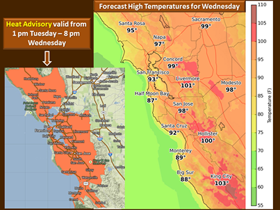
A HEAT ADVISORY MEANS THAT A PERIOD OF HOT TEMPERATURES IS EXPECTED. THE COMBINATION OF HOT TEMPERATURES AND HIGH HUMIDITY WILL COMBINE TO CREATE A SITUATION IN WHICH HEAT ILLNESSES ARE POSSIBLE. DRINK PLENTY OF FLUIDS…STAY IN AN AIR-CONDITIONED ROOM…STAY OUT OF THE SUN…AND CHECK UP ON RELATIVES AND NEIGHBORS.
|
Overview A strong ridge of high pressure combined with light offshore winds will bring very warm to hot conditions to the San Francisco and Monterey Bay Region Tuesday through Thursday. |
CONFIDENCE
· High Confidence for hot weather Tuesday and Wednesday.
· Medium to high confidence that hot weather will last through Thursday.
UPDATED INFORMATION
· Upgraded Watch to Advisory. A Heat Advisory has been issued Tuesday and Wednesday for most areas.
· Temperatures will be mid 80s to mid 90s near the coast and bays with mid 90s to 104 inland.
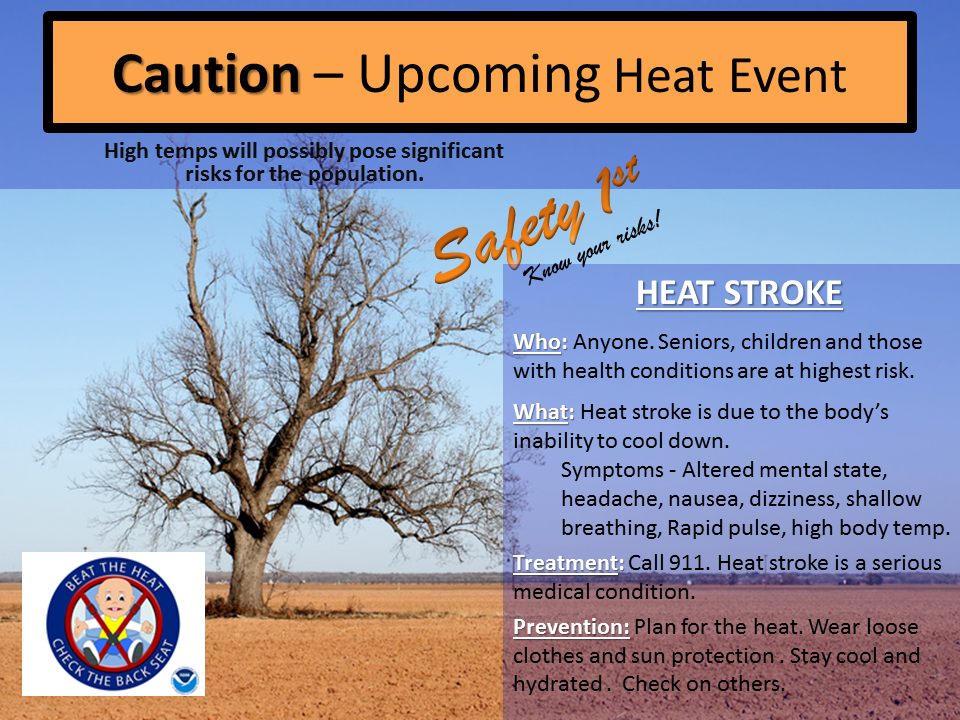
· See attached images for details including heat safety tips
TIMING
· Warm temperatures will turn hot by Tuesday and Wednesday with record or near record warmth likely. Overnight lows will stay mild as well and exacerbate the hot conditions. Some cooling will likely occur near the coast by Thursday but hot weather will continue inland. All areas should see significant cooling by Friday and into next weekend.
LOCATIONS
· All areas will see hot temperatures but the biggest concern is for urban locations such as San Francisco, San Jose and Oakland.
· The Heat Advisory does NOT include the Sonoma/Marin or San Mateo Coastlines. Also interior portions of Monterey and San Benito are not included because temperatures of 105-115 are not expected.
· Nonetheless all areas will be impacted by the hot temperatures this week.
IMPACTS
*Hazards:
· Heat Advisory in effect from 1 pm Tuesday through 8 pm Weds.
· http://www.srh.noaa.gov/data/MTR/NPWMTR
*Impact 1 :
· The hot weather will likely lead to health related issues for individuals who are the most sensitive to heat such as the elderly and those on certain medications. First responders will likely see a noticeable increase in routine calls and dispatches.
*Impact 2:
· Temperatures in vehicles will rapidly rise…leading to very dangerous conditions for children or animals. Beat the heat, check the back seat.
*Impact 3:
· Lower humidity readings are expected along with light offshore winds and very dry fuels. Fire weather conditions will become near critical as fuels continue dry out. Days when temperatures are above 90 with low humidity often see an increase in new fire starts. Any source of ignition will have a higher likelihood of new starts including: downed power-lines, auto-accidents, construction sites, ag burns that were presumed to be out as well as outdoor barbecues.

