|
Overview The second in a series of Pacific Storms will bring rainfall to the Bay Area this week. Rain will begin Tuesday morning and wet weather will continue through Thursday. This storm system will bring locally heavy rain, isolated thunderstorms and stronger winds. |
CONFIDENCE
·Moderate-high confidence
UPDATED INFORMATION
·Initial briefing for this storm.
TIMING
- Rain begins Tuesday morning by daybreak and continues through Thursday. The heaviest rain will be Tuesday and Wednesday.
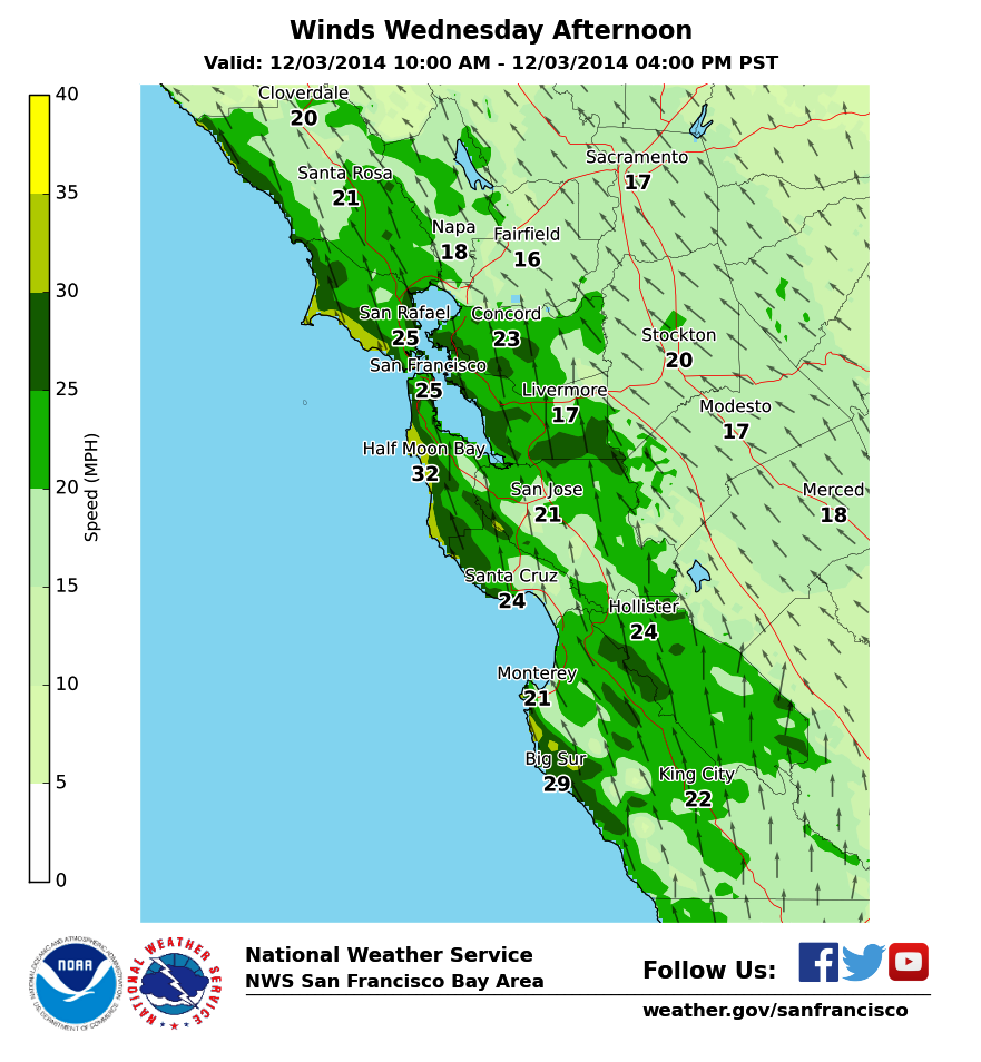
- Southerly winds increase Tuesday morning. The strongest winds will be Wednesday afternoon.
LOCATIONS OF GREATEST IMPACTS
·Rainfall totals with this storm:
oUrban locations: 1 – 2 inches
oCoastal mountains: 2 – 4 inches. Up to 5 inches possible in the Santa Cruz and Santa Lucia Mountains.
·Strongest winds: coastal areas and higher elevations
·Minor flooding: low lying, poorly drained, and urban areas, small creeks.
·Debris flow: Pfieffer Burn Scar in Big Sur. Other minor debris flows and rock slides possible.
IMPACTS
* Hazards:
·No watches/warnings/advisories in effect at this time. Click for latest here.
·Hazardous Weather Outlook: http://1.usa.gov/1rdTkiL
·Hydrologic Outlook: http://1.usa.gov/1ruGIyg (will be updated this afternoon)
* Impact 1 (Minor Flooding) :
·The ground is not yet saturated this season, so flooding concerns will mainly be confined to low-lying and poorly drained areas, especially in urban areas, and some minor flooding of small streams.
·Large rivers are not expected to have flooding concerns.
·Clogged storm drains will worsen localized urban and street flooding.
·Flooding may be more likely near the coast during high tides.
* Impact 2 (Strong Winds):
·Wind gusts may bring down trees and potentially power lines, especially in the hills and near the coast where winds will be strongest.
· Coastal winds 25 to 35 mph with gusts to 40 mph expected Tuesday and Wednesday. Similar winds in the hills over 1500 feet elevation.
* Impact 3 (Moderate-Heavy Rainfall ):
·Wet roadways, especially for the Tuesday morning commute.
·Isolated thunderstorms possible along the coast Tuesday and Wednesday. Small hail will be possible in any thunderstorms that develop.
*Impact 4 (Drought Conditions):
·This upcoming rainfall will beneficial to our area and while it may provide some short term benefits, it is only just a step in the right direction. California’s present drought has evolved over several years’ worth of rainfall deficits, and one storm will not completely end the significant impacts across the state.
·It will still be important for Californians to conserve water and heed the advice of statewide water management agencies, despite any short term improvements that are observed. It will take several more storms in the next few months to make a significant or long-lasting improvement to California’s drought conditions.
